
The C-Nav system is a global, real-time, decimeter accurate GPS system. What we call a GcGPS system (Globally Corrected GPS). C-Nav corrections are not based on traditional pseudo range DGPS. C-Nav is a new concept in GPS positioning, where the accuracy at the mobile location is no longer a function of the distance from the reference station(s).
This application is a product of 10 years of research and development. NASA’s Jet Propulsion Laboratory (JPL) has conducted the majority of this research in their pursuit to provide centimeter accuracy in space. This technology is now being used to provide sub-meter positioning around the world.
C-Nav uses a global network of reference sites strategically located around the world to simultaneously track and monitor the entire GPS constellation. Two independent and redundant, Network Processing Hubs (NPH) are utilized to receive raw, dual frequency GPS, code and phase GPS observable data from the reference sites to calculate orbit and clock corrections for each satellite in the GPS constellation. These corrections are packaged and up-linked to the INMARSAT communication satellites for global broadcast to all C-Nav users in real-time.
The C-Nav GPS receiver applies the received orbit and clock corrections plus the internally computed, dual frequency, refraction corrected pseudo ranges to compute a 3D surface position.
C-Nav GcGPS operates in real time, providing seamless global coverage and decimeter capable positioning in the offshore world, between the latitudes of 75 degrees North and South. A survey crew operating C-Nav is not concerned with distances from reference stations - they are free to operate worldwide.
Traditional DGPS systems experience accuracy and stability errors as the distances between their receivers and reference sites change. C-Nav is a totally new concept in DGPS positioning, providing worldwide accuracies in the order of 25cm (1 sigma).
|


 The operation of offshore oil and gas production is constantly requires the support efforts from a great diversified of marine vessels, rigs, structures and Floating Production Storage Offloading (FPSO). For that reason, the availability of precise and reliable positioning is absolutely needed.
To meet this critical requirement, offshore positioning is typically based on Differential GPS (DGPS). Most construction and diving support operations, Remotely Operated Vehicles (ROV) and underwater surveys, pipe laying and others critical survey applications generally require 3 to 5 meter accuracy. Thus, DGPS is a key technique in these demanding conditions.
MGSB offers professional GPS solutions which ideally suit for offshore survey positioning applications. MGSB provides OmniStar DGPS, C-Nav DGPS and any other DGPS systems which preferred by clients. The DGPS system will be integrated to the state of art positioning and navigation computer system with QINSy survey software. We adopt the latest technology to provide precise navigational data for you.
The operation of offshore oil and gas production is constantly requires the support efforts from a great diversified of marine vessels, rigs, structures and Floating Production Storage Offloading (FPSO). For that reason, the availability of precise and reliable positioning is absolutely needed.
To meet this critical requirement, offshore positioning is typically based on Differential GPS (DGPS). Most construction and diving support operations, Remotely Operated Vehicles (ROV) and underwater surveys, pipe laying and others critical survey applications generally require 3 to 5 meter accuracy. Thus, DGPS is a key technique in these demanding conditions.
MGSB offers professional GPS solutions which ideally suit for offshore survey positioning applications. MGSB provides OmniStar DGPS, C-Nav DGPS and any other DGPS systems which preferred by clients. The DGPS system will be integrated to the state of art positioning and navigation computer system with QINSy survey software. We adopt the latest technology to provide precise navigational data for you. 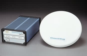
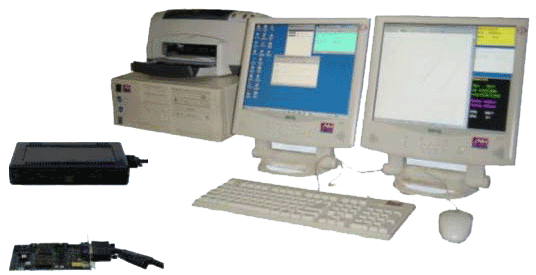 QINSy, a Quality Integrated Navigation System is the standard positioning and navigation software that MGSB used. QINSy has all the necessary characteristics in an integrated and compact solutions for various kind of positioning and navigation tasks.